
Conditions heated up in the Arctic, yet again, last week, as two storms swept up from the North Atlantic to cause temperatures near the North Pole to spike by nearly 30 oC over just a few days.
Temperatures near the North Pole underwent a dramatic rise - twice - in the latter half of last week, spiking to around 30 oC above normal for this time of the year.

This animation shows temperature anomalies (above or below the 1979-2000 average) for Thursday, February 9 through Sunday, February 12. Take note of what happens to the north of Greenland, as temperatures briefly spike near the top of the scale at the beginning of the animation, and then an even wider swath of heat sweeps through afterward. Credit: ClimateAnalyzer.org. Animation by S. Sutherland
Even as of the night of Feb 7-8, temperatures at the North Pole were still roughly average for this time of year, at around -30 oC. It only took until the end of the day, on Wednesday the 8th, for temperatures to spike upward as the first storm passed. Then, as that storm continued on and the second one approached, temperatures again dropped to near-normal and then rebounded even higher, as shown in the graphs below.
 |  |
 Graphs for three separate Arctic weather buoys that are currently near the North Pole, updated as of Feb 12, 2017. Darker colours in the buoy's location trace line (inset) indicate more recent records. Data courtesy University of Washington. Graphs by S. Sutherland | |
With these three buoys directly in the path of the warmth from both of these storms, one of them recorded a temperature rise from -29.8 oC to -6.4 oC and then up to -0.5 oC. Another went from -29.3 oC to -4.1 oC and then up to -0.1 oC. The third saw a rise from -28.5 oC to -1.0 oC, and then it actually exceeded zero degrees, to reach +1 oC!
What was driving this abrupt change in the weather?
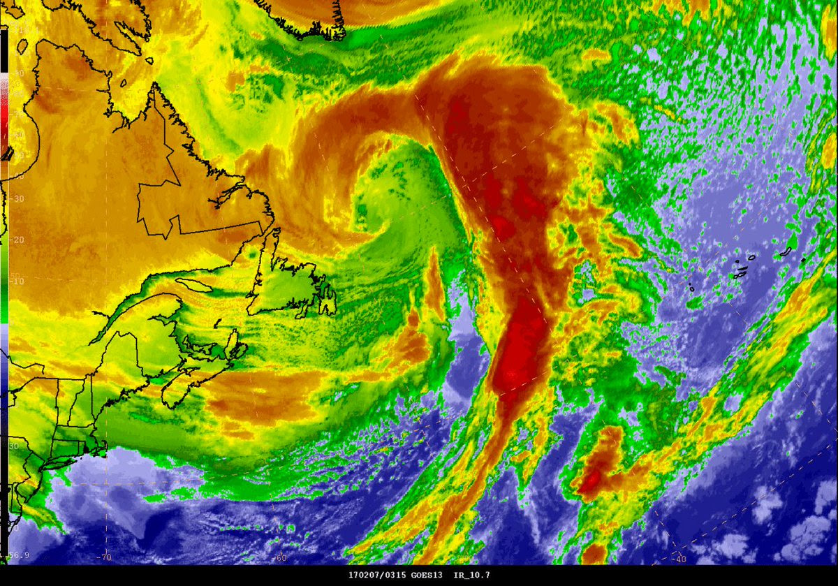
The first blast of heat was from a storm that was already in the Arctic early in the week, headed north of Greenland, and the second, more extreme event was from a powerful storm that'd been churning its way through the North Atlantic early in the week and made its way up over Greenland to arrive at the North Pole on Friday.
Here's what the second storm looked like on Tuesday morning, as the U.S. National Weather Service Ocean Prediction Center was watching it via satellite imagery.
So far in 2017, the U.S. National Snow and Ice Data Center has been logging the lowest sea ice extents in the Arctic on record, for nearly all of January, and all of February so far. There has only been a 5-day period, from Jan 24 to Jan 28, where the extent rose to only the second lowest on record (Jan 24-28, 2006 was the lowest for that time period).

Arctic sea ice extent, February 12, 2017, compared to all previous years. Closeup inset provides a better look at the individual years. Credit: NSIDC/S. Sutherland
Current sea ice extent in the Arctic is 13.9 million square kilometres - 286,000 sq km lower than it was just one year ago, which was the previous lowest extent on record, and nearly 1.4 million sq km lower than the 1981-2010 average.
The Barents Sea - the region of the Arctic Ocean to the north of Europe - is already where the ice extent is suffering most this year, so this will only add to the problem there.

Arctic Sea ice extent, as of Feb 12, 2017, mapped on NASA's Blue Marble (compared to the 1981-2010 average). Credit: NSIDC
With the combination of strong winds from this North Atlantic storm and the temperatures driving up to around the melting point, rate of increase in Arctic sea ice extent flattened out last week - meaning there was little to no growth seen - and the extent even decreased as these storms passed, as the winds piled the ice up onto itself in the Barents Sea and the heat picked away at the edges of the ice. Given that this is the middle of the winter, when sea ice should be growing, fairly consistently, towards its yearly maximum, seeing the rate of growth go negative is not a good sign.
Combined with what's already happening in the Arctic so far this winter, we may be looking at a new lowest winter maximum for sea ice extent, and it also puts us on the path towards yet another lowest annual sea ice extent, after 2016 set a new record.
No comments:
Post a Comment